I write on behalf of Hoylake Neighbourhood Planning Forum [Hoylake Vision] to offer our response as a Statutory Consultee to notification of the Planning Application ref No APP/20/01047 – Demolition of the existing building and erection of a 3 storey building comprising 9 apartments (Use Class C3) with associated basement parking, servicing, landscaping and infrastructure. | Wirral Point, 37 STANLEY ROAD, HOYLAKE, CH47 1HN
Having reviewed the submitted documents against the Hoylake Neighbourhood Development Plan [NDP] and with reference to the previous application, ref APP/19/1602, at this site that was refused, we are totally unsupportive of this second proposal at this site and object to the proposal on the following grounds.
Measuring the submitted scheme against NDP Policy DI2. SCALE AND DESIGN OF NEW DEVELOPMENT we find the proposal does not fully address the distinctive character or reflect the identity of the area. The applicant’s architects, in their Planning Design Statement, reference 3 storey terrace blocks, none of which exist on Stanley Road or in the Meols Drive Conservation Area ]MDCA], as justification for the size/scale of the new development. In terms of its size, design and materials of construction simply stating that the new building will be constructed of red brick and terracotta roof tiles is the insufficient justification of reflecting the identity of the MDCA. Furthermore, the proposed building’s large areas of glazing mean it does not readily assimilate within its surroundings. On this basis, the application should be refused.
Measuring the submitted scheme against NDP Policy DI3. DESIGNATED HERITAGE ASSETS the proposed development adversely affects the significance of a designated heritage asset, by its total demolition, and the proposal by its very nature of building replacement does nothing to conserve or enhance the significance of the existing property. On this basis, the application should be refused.
Measuring the submitted scheme against NDP Policy H1. RESIDENTIAL DEVELOPMENT the proposed development does not accord with Policies DI2, DI3 (as mentioned above) and would have a significantly adverse effect upon the distinctive character of the local area and the living conditions of occupants of surrounding dwellings. The northeast elevation facing the directly adjacent property and presenting itself to the majority of Stanley Road is overbearing and ill-considered and would be very much to the detriment of the local area. On this basis, the application should be refused.
Measuring the submitted scheme against NDP Policy H2. HOUSING TYPE AND TENURE this proposed residential development does not address the housing needs of the wider community, does not provide a mix of housing types, tenures and sizes, or include any affordable and specialist housing. All of the 9 flats created are the same 3 bedroom format with no justification offered for this monotype development other than a contention that older locals wish to downsize and therefore free up larger local family-sized properties. Where is the market evidence that this is indeed a true statement by the applicant/agent? On this basis, the application should be refused.
Aside from the NDP, the submitted proposal to demolish and replace the existing building when measured against the protections afforded by the Meols Drive Conservation Area [MDCA] displays a wanton and willful disregard for established conservation policies and practices. The existing property in question, 37 Stanley Road, is identified as ‘Category B‘ (contributing positively to the MDCA) in the MDCA Appraisal Appendices; Plan Ref 189; Photo ref No3281. We disagree with the submitted proposal’s view that the MDCA character appraisal of 2004 being 16 years old is out of date and should therefore be disregarded. The proposal contends that the existing property does not represent the best of the Stanley Road properties and “the replacement building has been redesigned to be in harmony with the traditional character of the conservation area”. Simply stating that the new building will be constructed of red brick and terracotta roof tiles does not make the proposal of visual merit and greater contribution to the group value of the MDCA. Demolition of a building in good condition and perfectly habitable simply to subsequently redevelop the site and increase plot density does not contribute to the group value of the MDCA. On this basis, the application should be refused.
Aside from the NDP making reference to National Planning Policy Framework [NPPF], specifically Paragraph 195, the loss of a building which makes a positive contribution to the significance of the Conservation Area should be treated as substantial harm. We do not agree with the submitted Heritage Statement that the “limited interest of the existing building” affords the applicant the right to demolish it and replace it with a new building. Indeed the approval of this application would put every Category B building in the Meols Drive Conservation Area [MDCA] at risk of similar demolition and redevelopment. On this basis, the application should be refused.
In further reference to NPPF Paragraph 130 states that permission should be refused for development of poor design that fails to take the opportunities available for improving the character and quality of an area and the way it functions. The submitted proposal would dominate the end of Stanley Road by nature of its design being overly prominent in size, mass, elevation, height, footprint and higher density of occupation. The proposed new apartment block would adversely alter the appearance and the special features of this important area directly adjacent to the Red Rocks promontory. Furthermore, this new design is still discordant with its surroundings and would erode the historic character of the MDCA and the adjacent Royal Liverpool golf course. On this basis, the application should be refused.
By nature of its location on Stanley Road, the application site is within a density and design guidelines area. Supplementary Planning Guidance Note 5 [SPG5] identifies the proposed development site as falling within zone 5, within which purpose-built flat development should not be permitted. On this basis, the application should be refused.
The submitted Design & Access Statement includes the architect’s contention that the development will be “acting as a catalyst for all future development nearby“. Considering this alongside the assertions of the direct neighbour that he has already been approached by the applicant/developer seeking to purchase the adjacent property if this scheme were to be approved, it could set an unwanted precedent allowing this developer [or others] to seek to increase the density of future development along Stanley Road by demolition and replacement of other Category B properties with a resultant erosion of the character and/or undermine the pattern of development in the MDCA.
We would like to bring to your attention that the Community Planning Forum is currently developing a Design Code for Hoylake, which is being produced by consultants AECOM. This emerging document will form a central part of the NDP and Local Plan. The Design Code will provide evidence-based clarity around many of the above concerns including, notably, the important role both overall and individual plot density of development plays in identifying and protecting the distinctive character of the various parts of Hoylake while allowing for appropriately sited and scaled new development. On 6th August 2020, the UK Government published the White Paper “Planning for the future”: new planning guidance which considers Design Codes to be essential for future sustainable development. Under the proposals, land will be designated into one of three categories -– for growth, for renewal or for protection. By definition, a Conservation Area should rightfully be considered to be ‘protected’.
Further to our formal objections above we offer our commentary on the quality of the design as presented and issues we believe should be addressed when considering this application. Contrary to the assertions made in the planning statement the design as presented is not exemplar on a number of points, particularly fire safety regulations.
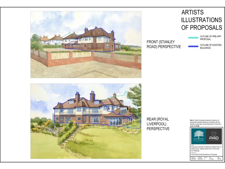
THE HEIGHT OF THE NEW BUILDING IS GREATER THAN THE EXISTING AND IS OVERBEARING
The Powers and Tiltman Topographical Survey, embedded within the Flood Risk Assessment, gives a spot level of the highest ridge of the existing building as +18.72
The proposed Cross Section, also embedded within the Flood Risk Assessment, notes the large central section of flat roof of the proposed building at a level of +19.80 more than a whole metre higher than the highest ridge of the existing building.
The proposed northwest elevation only hints at this much greater massing as the applicant’s architects have chosen to not show the wider street scene in elevation as it is clear this would be prejudicial against their overbearing proposal.
THE FOOTPRINT OF THE NEW BUILDING IS FAR GREATER THAN THE EXISTING
The only indication of the relative scale of the proposed footprint against the existing is embedded within the Flood Risk Assessment, Appendix A, drawing No RB20001-3. From this, it is clear that the increase in mass of the new building relative to the site would be significant.
PROTECTED ENTRANCE HALLS TOO LONG
Fire safety regulations dictate that protected entrance halls within flats on upper storeys are a maximum 9 metres in length, from the entrance door to the door into the furthest room. The submitted plans for the upper storeys exceed this.
SINGLE ESCAPE STAIR CANNOT CONTINUE DOWN TO BASEMENT
The submitted plans and proposed long section show a single stair which forms the only escape route from the upper storeys going all the way down to the basement. Fire safety regulations dictate that an escape stair forming part of the only escape route from an upper storey should not continue down to serve a basement storey. The basement storey should be served by a separate escape stair. The submitted plans do not show this.
FIRE STRATEGY NEEDS TO BE CONSIDERED FOR BASEMENT PARKING
The fire strategy plans do not include the basement level. This is particularly pertinent when that basement is a covered car park with increased risk of fire and that there is mention in the submitted documents of the introduction of electric vehicle [EV] charging points which would bring further additional risk of fire due to EVs incorporating high capacity batteries.
The scheme presented also includes open vents for natural ventilation of the basement car park with these vents directly below large windows of apartments above. Without fire strategy measures these present a fire risk and smoke hazard to the dwellings above should a basement fire occur. The submitted plans may need adaption to show this.
When considering sub-surface parking arrangements and fire safety all concerned should recall the scale of damage we saw in Liverpool in 2017 when one single vehicle with a fuel leak caused a huge fire in the Echo Arena Car Park.
VIABILITY OF BASEMENT PARKING
The architects state “The development aims to improve the front garden and public realm along Stanley Road by relocating parked cars to a basement car park. This approach will not only visually reduce the number of parked cars along Stanley Road but will heal a gap in the streetscape with well-considered built form of appropriate scale.”
The submitted Ground Conditions Report confirms that beneath the site is Helsby Sandstone. The proximity of Red Rocks, where this sandstone is exposed to view, gives a clear indication of the likely level of the bedrock sandstone on the site. This brings into question the validity and viability of creating a large sub-surface parking area on the site.
Further to this, the existence of a protected species, natterjack toad, and habitat on the site, both of which need to be protected during construction work further complicates excavating down 3m within a constrained area of available working room.
BASEMENT ACCESS RAMP TOO SHORT FOR REQUIRED GRADIENT
The basement vehicle access ramp as presented is not large enough, of sufficient length in plan, to achieve a sufficiently shallow gradient to a subterranean level some 2.8m below ground [documented in the section shown in the flood risk and drainage assessment with ground floor level noted as +8.70 and basement level as +5.90]. A curved access ramp for vehicles requires a shallower gradient than the usual 1 in 10 slope of a straight ramp for vehicles and will need to include a shallower transition section at either end. On this basis what is shown on the submitted plans is far too short a distance to achieve vehicular access to the basement.
Finally, we would reiterate that Hoylake Neighbourhood Planning Forum [Hoylake Vision] are totally unsupportive of this second proposal at this site and object to the application.
Yours sincerely,
Julian Priest
On behalf of Hoylake Neighbourhood Planning Forum [Hoylake Vision]